While Southland has a strong regional identity, its communities are spread across a large geographic area. The Commission considers it unlikely that electing councillors at-large across Southland would result in effective representation for communities dispersed across a large geographic area. Wards have been proposed to ensure that distinct parts of Southland are represented on Southland Council.
In designing the ward structure, the Commission considered both fair representation, so that councillors generally represent similar numbers of people, and effective representation, so that distinct communities are not divided or combined in ways that weaken their voice.
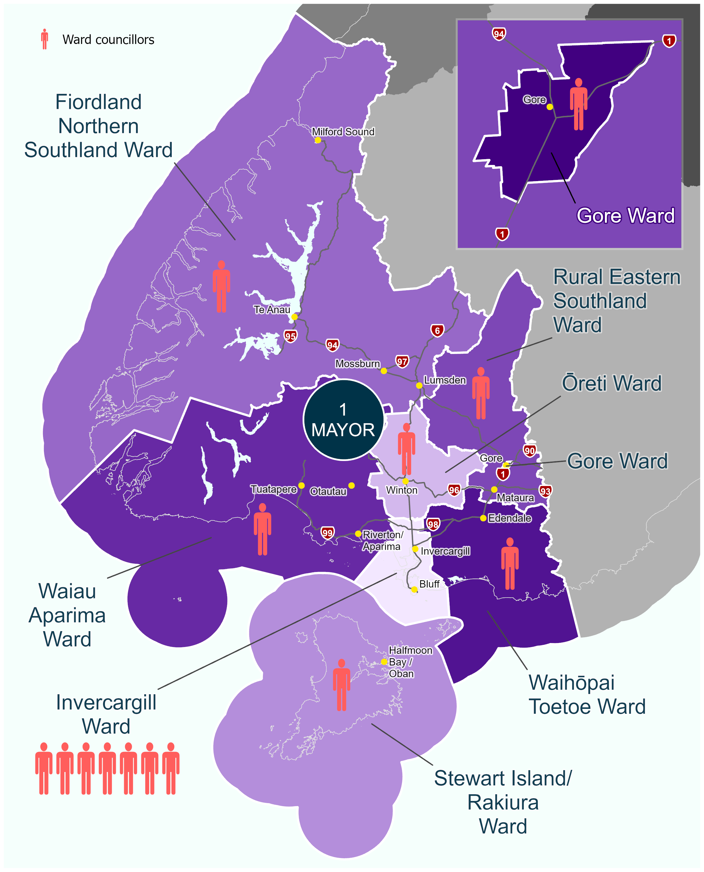
Southland would be divided into eight wards for the purpose of electing councillors to Southland Council. The wards aim to reflect Southland’s major communities of interest while also providing fair and effective representation for electors.
Southland’s communities are not defined solely by existing council boundaries. The Commission has considered existing council, ward, community board and subdivision boundaries, but these have not necessarily been retained, where there is evidence that communities extend across them. Some have been altered to better reflect communities of interest or, where appropriate, to follow geographic features.
The proposed wards are as follows:
Table 1: Ward representation by population
| Ward |
Population* |
Councillors |
Population per councillor |
+/- 10% variance |
| Stewart Island/Rakiura |
500 |
1 |
500 |
-93.32 |
| Invercargill |
59,800 |
7 |
8,543 |
+14.06 |
| Ōreti |
7,860 |
1 |
7,860 |
+4.92 |
| Waihōpai Toetoe |
6,820 |
1 |
6,820 |
-8.95 |
| Rural Eastern Southland |
7,120 |
1 |
7,120 |
-4.94 |
| Gore |
8,030 |
1 |
8,030 |
+7.21 |
| Fiordland Northern Southland |
6,630 |
1 |
6,630 |
-11.48 |
| Waiau Aparima |
8,100 |
1 |
8,100 |
+8.14 |
| Total |
104,860 |
14 |
7,490 |
|
*Based on Stats NZ 2025 population estimates (2023 census base).
Not all proposed wards comply with the +/-10% fair representation requirements, as explained further below. The law allows exceptions where necessary to provide effective representation for isolated or distinct communities of interest. The Commission considers this is particularly relevant for communities such as Stewart Island/Rakiura and for geographically large wards.
In reaching its proposed ward arrangements, the Commission considered:
- The distinct identity and geographic isolation of Stewart Island/Rakiura
- The importance of Gore as a separate urban community and service centre;
- The role of Invercargill as Southland’s principal urban centre;
- Strong communities of interest identified in Fiordland, Northern Southland, Central Southland, Western Southland, and Eastern Southland; and
- The need to provide representation for large rural areas where travel distances and differing local circumstances create challenges for effective representation.
What do the ward boundaries look like?
A brief description of each ward is provided below:
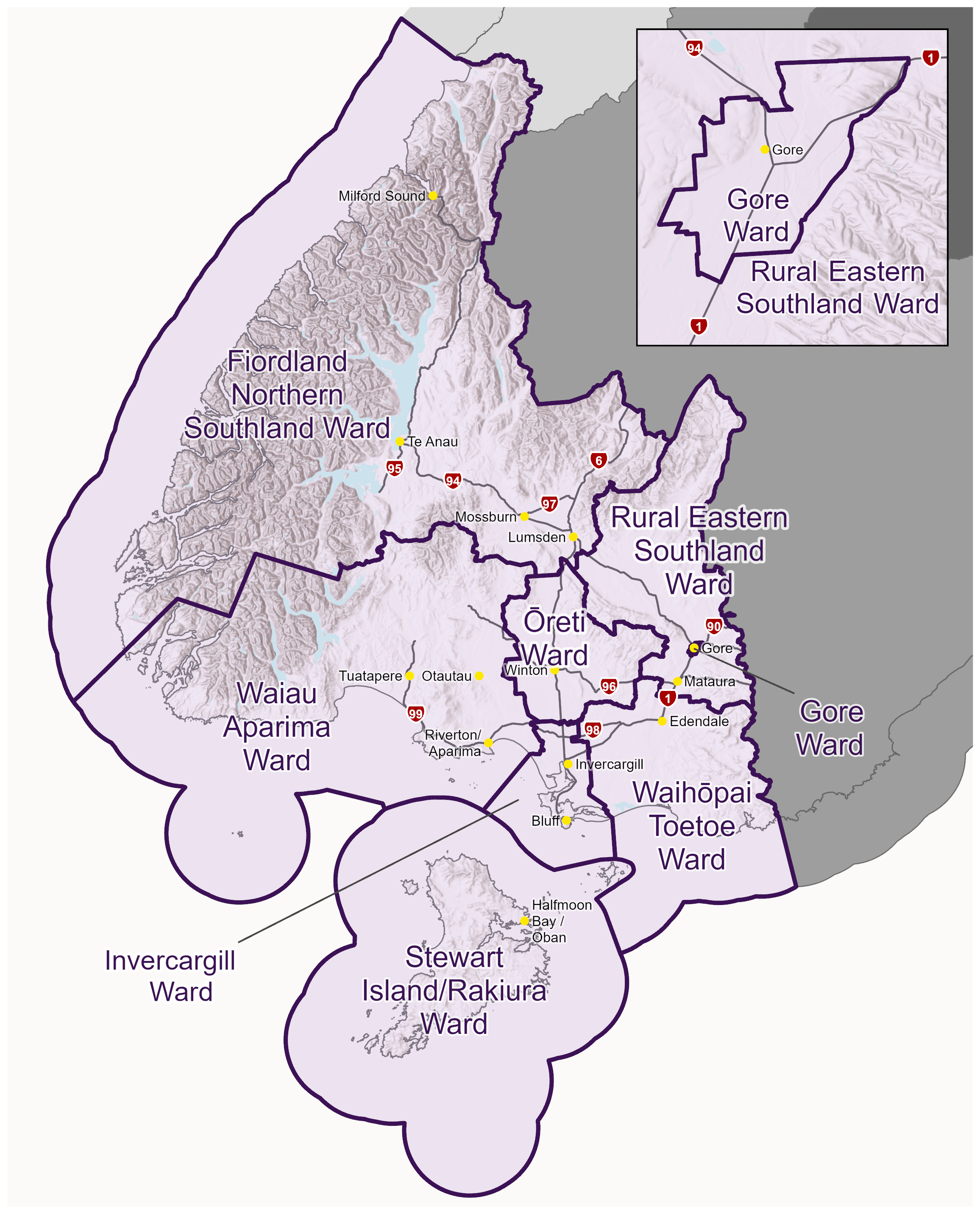
- Stewart Island/Rakiura Ward comprises Stewart Island/Rakiura and reflects the island’s strong identity, physical separation from the mainland, and longstanding recognition as a distinct community of interest. The ward boundaries follow current ward boundaries.
- Invercargill Ward comprises the wider Invercargill area, including Bluff, together with closely connected fringe communities to the north-west, including Makarewa, Lorneville and Wallacetown. The Invercargill Ward is therefore expanded beyond the current Invercargill City boundaries. The ward reflects Invercargill’s role as Southland’s principal urban centre and service hub and recognises the close functional relationship that rural fringe communities hold with Invercargill.
- Ōreti Ward comprises central Southland and surrounding rural communities, centred on Winton as the immediate service centre for central Southland. It reflects the strong functional and community relationships associated with central Southland.
- Waiau Aparima Ward comprises western Southland communities centred around Riverton/Aparima, Tuatapere and Otautau. It reflects both the shared identity of western Southland and the distinct communities within it. The ward boundaries follow current ward boundaries.
- Waihōpai Toetoe Ward comprises communities along and inland from the south-eastern Southland coastline, including the Edendale, Wyndham, Woodlands, Tokanui and Fortrose areas. The ward boundaries follow current ward boundaries.
- Gore Ward comprises the urban Gore area, recognising Gore as a distinct urban community with a longstanding identity and role as the principal service centre for eastern Southland. The ward boundaries follow current ward boundaries.
- Rural Eastern Southland Ward comprises the rural townships and communities in the eastern Southland area that generally look towards Gore for services. This includes the communities of Mataura, Waikaia, Waimumu, Riversdale, Balfour and St Patricks, and includes the area previously within the Ardlussa Community Board.
- Fiordland Northern Southland Ward comprises Fiordland and northern Southland, including the areas previously within the Fiordland and Northern Community Boards. While these areas maintain distinct local communities, the Commission considers that they share sufficient common functional interests and geographic relationships to support a common ward.
The indicative ward maps are as follows:
Map 1: Wards and boundaries for proposed Southland Council
Map 2: Proposed councillor representation
Why do some proposed wards not comply with the +/-10% rule?
The Local Electoral Act generally requires each councillor to represent a similar number of people, within +/-10%. This is known as the +/-10% rule. However, the Act also recognises that strict population equality may not always provide for effective representation of communities of interest, and allows specific departures from the +/- 10% rule:
- To provide effective representation for island or isolated communities;
- To avoid dividing communities of interest;
- To avoid uniting communities of interest with few commonalities of interest.
The Commission has considered whether ward boundaries could be adjusted to achieve greater compliance with the +/-10% rule. However, changing boundaries to achieve compliance would either result in splitting identified communities of interest or combining communities with relatively weaker connections. The Commission considers that the exceptions to the +/-10% rule outlined below strike a better balance between fair representation and effective representation of communities of interest.
For Southland Council, the Commission has proposed that the following wards are justified in not meeting the +/-10% rule, as follows:
- Stewart Island/Rakiura is an island community and maintains a strong community of interest distinct from the mainland. There is a significant departure from the +/-10% rule, at -93.32%. The Commission considers this is necessary for a geographically isolated island community that has distinct infrastructure, transport and governance needs, and would unlikely be effectively represented within a mainland ward.
- Invercargill is Southland’s principal urban community and service centre. At +14.06%, a small departure from the +/-10% rule is considered necessary to avoid splitting the wider Invercargill urban area and neighbouring fringe communities that have strong functional relationships with the city.
- Fiordland Northern Southland includes distinct communities that share strong transport and functional links. At -11.48%, this is slightly outside the +/-10% rule. However, the Commission considers changing the boundary to achieve compliance would require adding additional communities to the ward which have weaker connections to Fiordland and Northern Southland and would be unlikely to enhance effective representation.
