The Commission proposes nine local boards across Southland. Each local board would comprise elected members from the local board area, along with one councillor elected from the corresponding ward. Each local board would elect its own chairperson from among its elected members.
The proposed nine local boards have been designed around recognised communities of interest and at a scale intended to maintain accessible local representation. The proposed local board boundaries generally reflect sub-regional and local communities of interest identified through the Commission’s communities of interest analysis. You can read the communities of interest analysis here.
The proposed number of members for each local board considers the characteristics of each local board, including population, geography, accessibility and the number and distribution of communities within each area.
Most local boards are proposed to be subdivided, to ensure a geographic spread of representation and ensure that smaller communities are not overlooked within a larger local board area. Subdivisions have not been proposed for the Stewart Island/Rakiura or Gore Local Boards, as the Commission considers doing so is unlikely to improve effective local representation.
Where a local board is divided into subdivisions, the Commission has also considered the balance between fair representation and effective representation of communities of interest. Some proposed subdivisions fall outside the +/-10% rule. In these cases, the Commission considers that altering boundaries to achieve compliance could divide established communities of interest or result in less effective local representation. These departures from the +/-10% rule are explained under each relevant local board below.
The proposed local boards are:
- Stewart Island/Rakiura Local Board
- Bluff South Invercargill Local Board
- Invercargill Northern Communities Local Board
- Ōreti Local Board
- Waiau Aparima Local Board
- Waihōpai Toetoe Local Board
- Gore Local Board
- Rural Eastern Southland Local Board
- Fiordland Northern Southland Local Board.
The proposed local board areas generally align with the proposed wards, reflecting Southland’s identified subregional and local communities. The exception is the Invercargill Ward, where two local boards have been proposed. Given the ward’s larger population base and the range of distinct communities within it, the Commission considers that a single local board would be unlikely to provide effective representation across the whole ward.
State Highway 1 is proposed as the boundary between the two Invercargill local boards. It provides a clear boundary line, while seeking to reflect the connections between surrounding communities and different parts of Invercargill. The Commission is interested in community feedback as to whether the proposed Invercargill local boards appropriately reflect communities of interest.
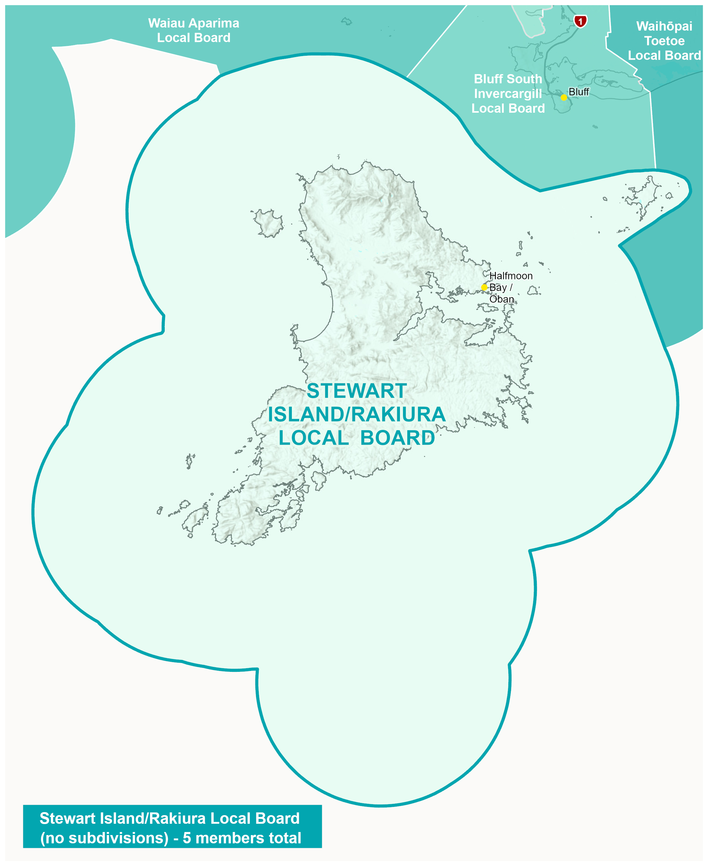
Stewart Island/Rakiura Local Board
The Stewart Island/Rakiura Local Board would represent the Stewart Island/Rakiura community. The Commission considers Stewart Island/Rakiura to be one of Southland’s most distinct communities of interest, reflecting its island location, unique transport and infrastructure challenges, and strong local identity. The Board would elect five members at large:
Table 2: Stewart Island/Rakiura Local Board representation by population
| Local Board/ Subdivisions |
Population* |
Board members |
Population per members |
+/- 10% variance |
| Stewart Island/Rakiura |
500 |
5 |
100 |
n/a |
*Based on Stats NZ 2025 population estimates (2023 census base)
Map 3: Stewart Island/Rakiura Local Board
Bluff South Invercargill Local Board
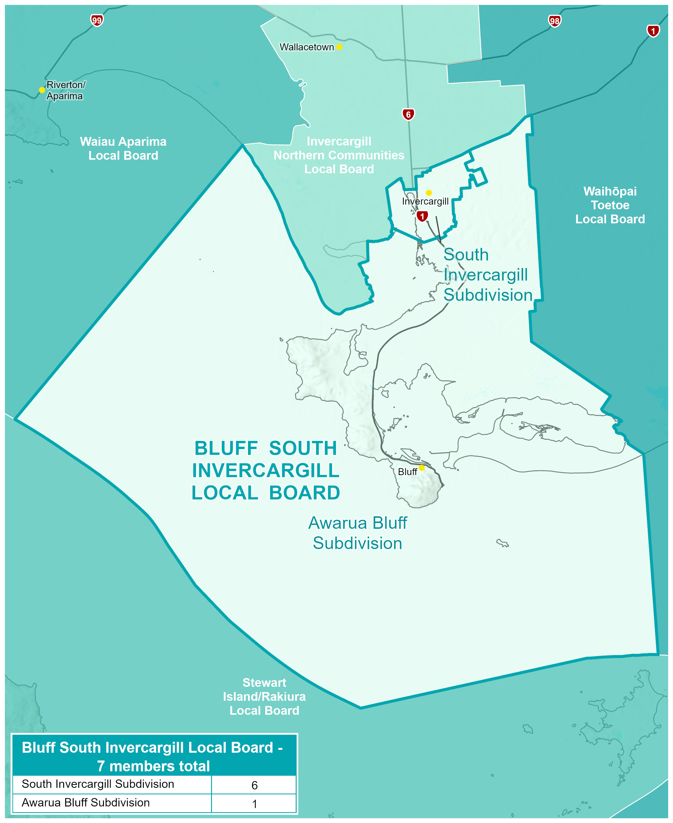
The Bluff South Invercargill Local Board would represent Bluff, Awarua, Woodend and the urban part of Invercargill south of Tay Street. The Board recognises the distinct identity of Bluff and the rural areas on the southern fringe of Invercargill, while also acknowledging the strong functional and economic links that exist between Bluff and Invercargill, including direct transport links with the south Invercargill area.
The Board would be elected from separate subdivisions as follows:
Table 3: Bluff South Invercargill Local Board representation by population
| Local Board/ Subdivisions |
Population* |
Board members |
Population per members |
+/- 10% variance |
| Awarua Bluff |
3,650 |
1 |
3,650 |
0.00 |
| South Invercargill |
21,900 |
6 |
3,650 |
0.00 |
| Total |
25,550 |
7 |
3,650 |
|
*Based on Stats NZ 2025 population estimates (2023 census base)
Map 4: Bluff South Invercargill Local Board
Invercargill Northern Communities Local Board
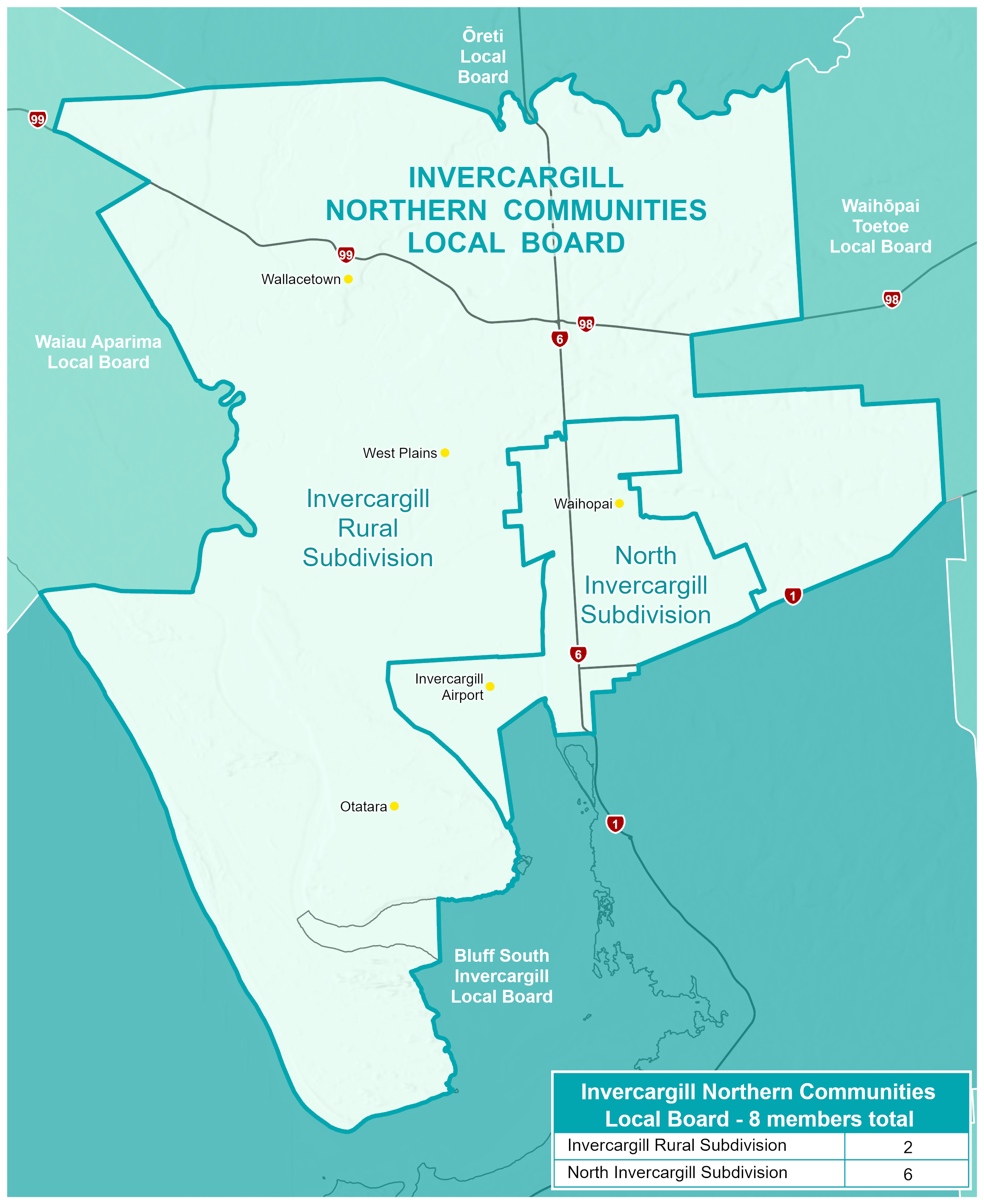
The Invercargill Northern Communities Local Board would represent the wider Invercargill urban area north of Tay Street, together with nearby rural fringe communities including Otatara, Makarewa, Lorneville, Wallacetown and Myross Bush.
The board would be elected from separate subdivisions as follows:
Table 4: Invercargill Northern Communities Local Board representation by population
| Local Board/ Subdivisions |
Population* |
Board members |
Population per members |
+/- 10% variance |
| North Invercargill |
25,700 |
6 |
4,283 |
+0.28 |
| Invercargill Rural |
8,470 |
2 |
4,235 |
-0.85 |
| Total |
34,170 |
8 |
4,271 |
|
*Based on Stats NZ 2025 population estimates (2023 census base)
Map 5: Invercargill Northern Communities Local Board
Ōreti Local Board
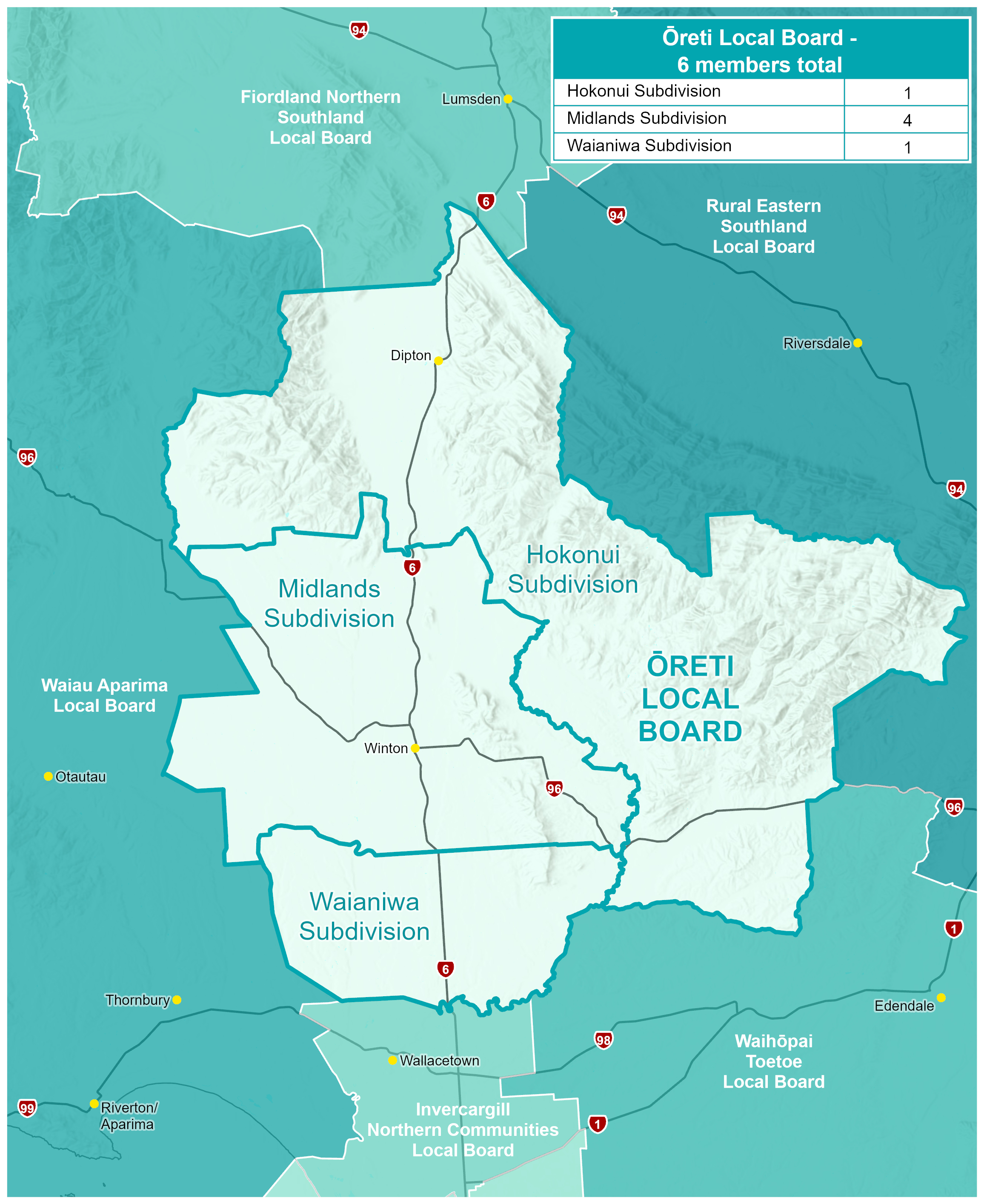
The Ōreti Local Board would represent central Southland and surrounding rural communities centred on Winton. The Commission considers the area to be a well-established community of interest with strong agricultural, educational, sporting and social connections.
The board would be elected from three subdivisions, being the Hokonui, Midlands and Waianiwa subdivisions. These subdivisions are similar to those in the current Ōreti Community Board, with the following changes:
- The southern boundary of the Midlands subdivision has moved northwards to align along Forest Hill Crossing Road;
- The Waianiwa subdivision takes in the southern part of the local board area, from North Makarewa/Grove Bush through to Forest Hill Crossing Road. The name of the subdivision recognises that Makarewa has moved into the Invercargill Northern Communities Local Board.
Table 5: Ōreti Local Board representation by population
| Local Board/ Subdivisions |
Population* |
Board members |
Population per members |
+/- 10% variance |
| Hokonui |
1,250 |
1 |
1,250 |
-4.43 |
| Midlands |
5,330 |
4 |
1,333 |
+1.83 |
| Waianiwa |
1,270 |
1 |
1,270 |
-2.90 |
| Total |
7,850 |
6 |
1,308 |
|
*Based on Stats NZ 2025 population estimates (2023 census base)
Map 6: Ōreti Local Board
Waiau Aparima Local Board
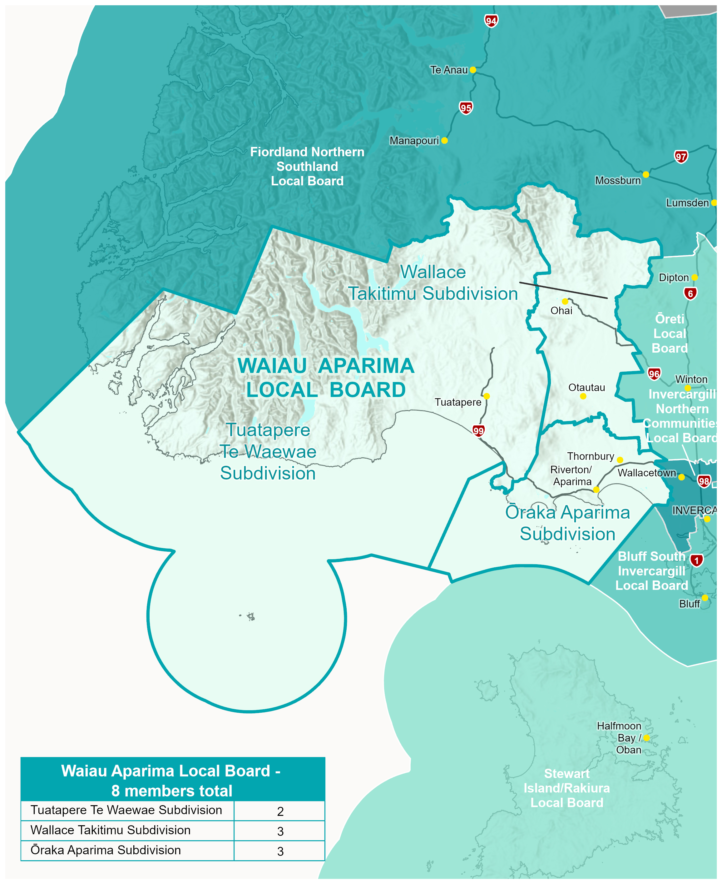
The Waiau Aparima Local Board would represent the communities of western Southland, including Riverton/Aparima, Otautau, Ohai, Nightcaps and Tuatapere. While the area contains several distinct communities, the Commission considers these communities share a strong western Southland identity.
The board would be elected from three subdivisions, being the Tuatapere Te Waewae, Wallace Takitimu and Ōraka Aparima subdivisions. These subdivisions follow the current community board areas.
The Tuatapere Te Waewae subdivision falls outside of the +/-10% rule, at -14.12%, and would need to gain population from either the Wallace Takitimu or Ōraka Aparima subdivisions to comply. However, the Commission considers that moving the boundary would risk splitting communities of interest strongly connected with Colac Bay and Riverton/Aparima (in the Ōraka Aparima subdivision), or Nightcaps and Ohai (in the Wallace Takitimu subdivision).
Table 6: Waiau Aparima Local Board representation by population
| Local Board/ Subdivisions |
Population* |
Board members |
Population per members |
+/- 10% variance |
| Tuatapere Te Waewae |
1,740 |
2 |
870 |
-14.12 |
| Ōraka Aparima |
3,080 |
3 |
1,027 |
+1.38 |
| Wallace Takitimu |
3,280 |
3 |
1,093 |
+7.98 |
| Total |
8,100 |
8 |
1,013 |
|
*Based on Stats NZ 2025 population estimates (2023 census base)
Map 7: Waiau Aparima Local Board
Waihōpai Toetoe Local Board
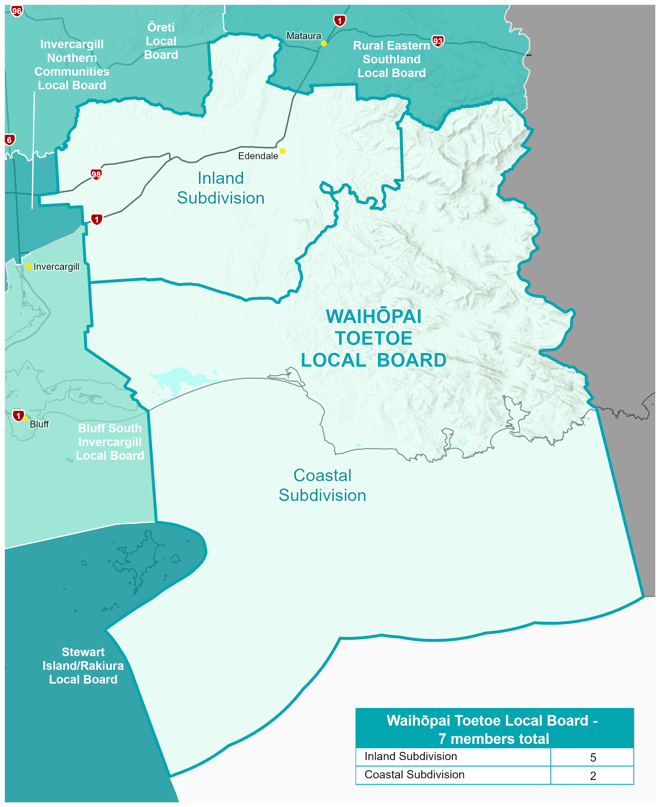
The Waihōpai Toetoe Local Board would represent south-eastern Southland communities, including Edendale, Wyndham, Woodlands, Tokanui, Fortrose and surrounding rural areas. The board reflects strong rural and community connections across the area while recognising differences between inland and coastal communities.
The board boundaries follow the current Waihōpai Toetoe Community Board area, which does not currently have subdivisions. However, given the geographic size of the board and the spread of communities across the board, the Commission has proposed electing members from Inland and Coastal subdivisions, to ensure a spread of members across the board area.
The Coastal Subdivision is outside the +/-10% rule at -18.81%. It includes dispersed coastal communities and the Southland part of the Catlins, with distinct tourism and farming activities. Achieving compliance would require moving the boundary to add population from the Inland Subdivision, which includes Wyndham, Edendale and communities along State Highway 1. The Commission considers that moving boundaries for this purpose would likely split communities of interest in the Inland subdivision.
Table 7: Waihōpai Toetoe Local Board representation by population
| Local Board/ Subdivisions |
Population* |
Board members |
Population per members |
+/- 10% variance |
| Inland |
5,230 |
5 |
1,046 |
+7.52 |
| Coastal |
1,580 |
2 |
790 |
-18.81 |
| Total |
6,810 |
7 |
973 |
|
*Based on Stats NZ 2025 population estimates (2023 census base)
Map 8: Waihōpai Toetoe Local Board
Gore Local Board
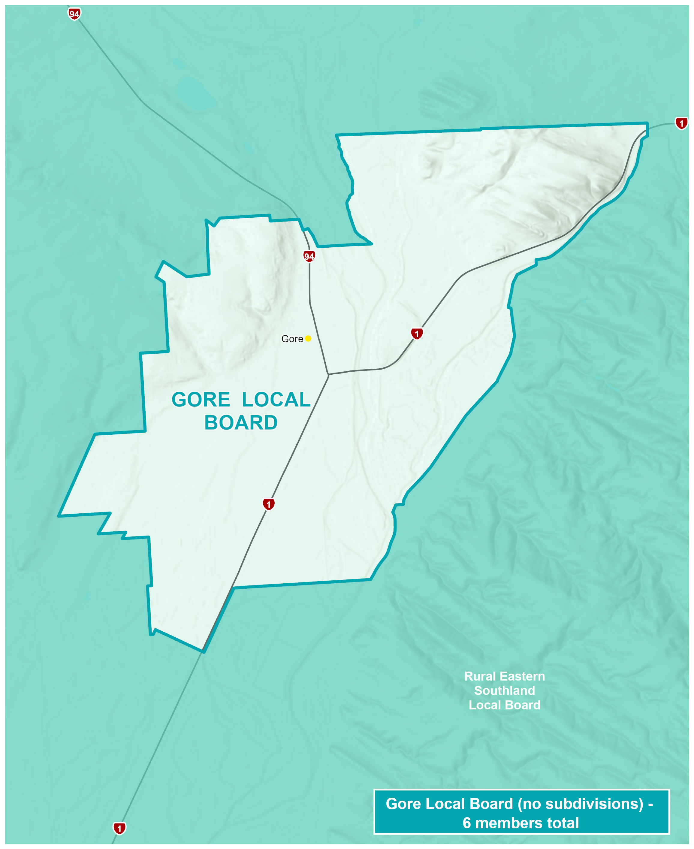
The Gore Local Board would represent the urban Gore community. Gore has consistently been identified throughout the Commission’s investigations as a distinct community and the principal service centre for eastern Southland.
The board would elect six members at large.
Table 8: Gore Local Board representation by population
| Local Board/ Subdivisions |
Population* |
Board members |
Population per members |
+/- 10% variance |
| Gore |
8,030 |
6 |
1,338 |
n/a |
*Based on Stats NZ 2025 population estimates (2023 census base)
Map 9: Gore Local Board
Rural Eastern Southland Local Board
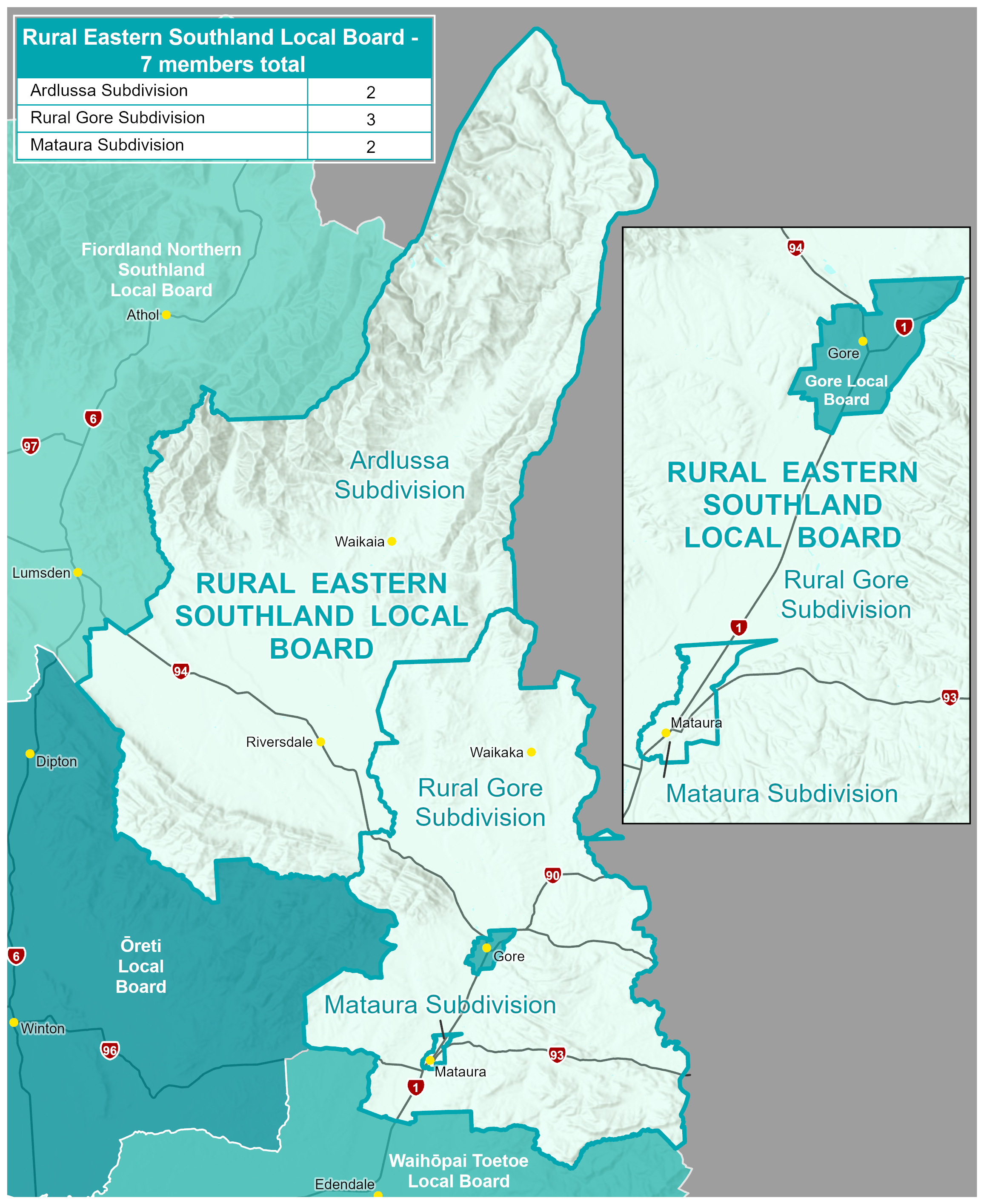
The Rural Eastern Southland Local Board would represent the rural areas surrounding Gore, including Mataura, Ardlussa and linked rural areas. The Commission considers these communities to share strong common interests and functional connections with Gore, while also maintaining their own identities.
The board would be elected from three subdivisions, being the Mataura, rural Gore and Ardlussa subdivisions. These subdivisions recognise the strong Mataura community of interest, while also recognising the dispersed geographic nature of the communities in the rural Gore and Ardlussa areas.
The proposed Mataura Subdivision is outside the +/-10% rule, at -17.89%. The Commission considers that Mataura is a strong and distinct community of interest, reflecting the current separate ward within Gore District. Achieving compliance would require expanding the proposed subdivision boundaries into surrounding rural areas to gain population. The Commission considers that doing so would likely split communities of interest in the Rural Gore subdivision.
Table 9: Rural Eastern Southland Local Board representation by population
| Local Board/ Subdivisions |
Population* |
Board members |
Population per members |
+/- 10% variance |
| Mataura |
1,670 |
2 |
835 |
-17.89 |
| Rural Gore |
3,270 |
3 |
1,090 |
+7.18 |
| Ardlussa |
2,180 |
2 |
1,090 |
+7.18 |
| Total |
7,120 |
7 |
1,017 |
|
*Based on Stats NZ 2025 population estimates (2023 census base)
Map 10: Rural Eastern Southland Local Board
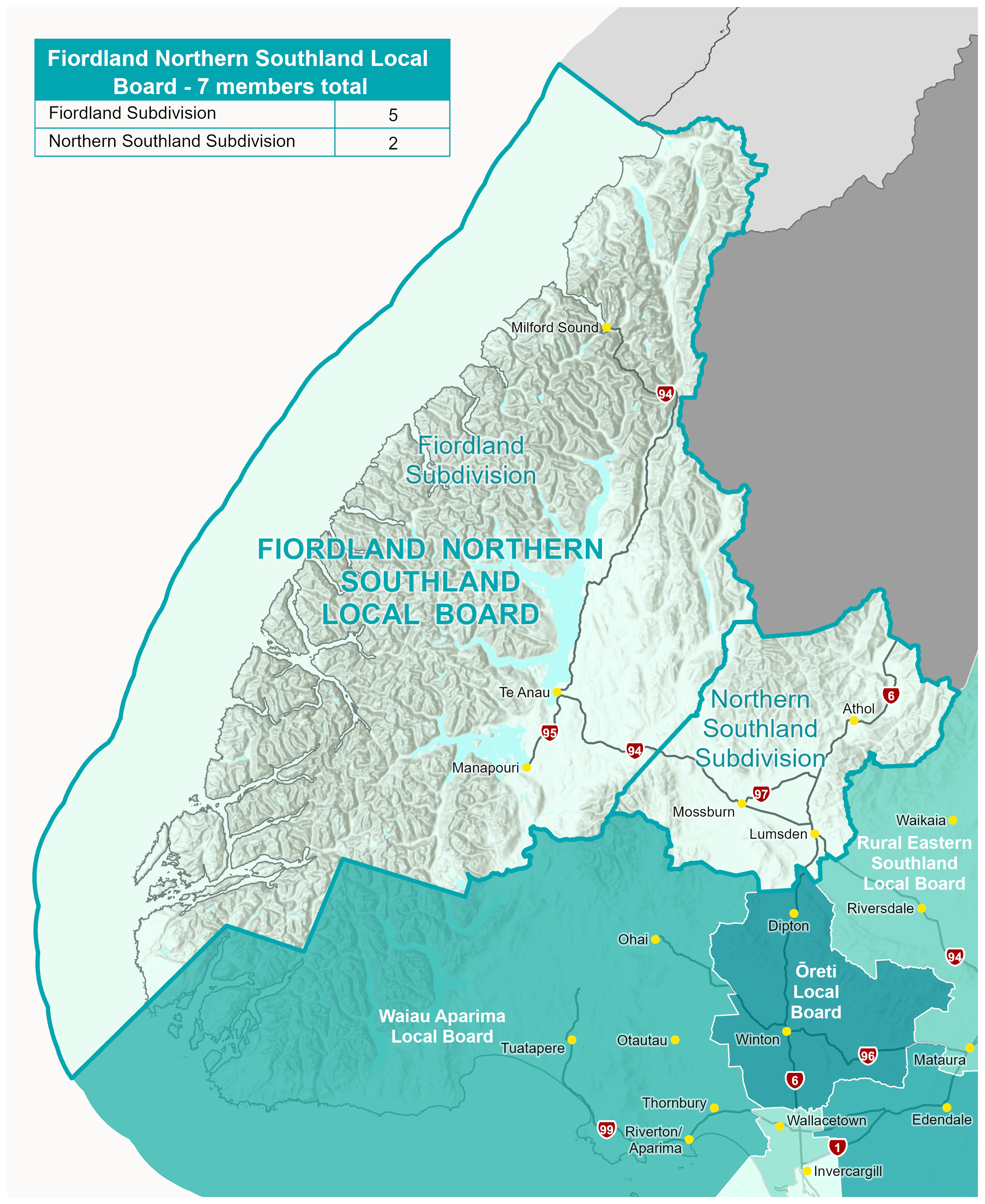
Fiordland Northern Southland Local Board
The Fiordland Northern Southland Local Board would represent both the Fiordland and Northern Southland communities. While Fiordland and Northern Southland are distinct communities, the Commission considers they have enough in common to support a shared local board, while subdivisions would ensure each area has its own representatives.
The board would be elected from the Fiordland and Northern Southland subdivisions. The current Northern Community Board has three subdivisions. The Commission proposes replacing these with a single Northern Southland subdivision, recognising the common rural interests and functional connections between communities including Mossburn and Lumsden.
Table 10: Fiordland Northern Southland Local Board representation by population
| Local Board/ Subdivisions |
Population* |
Board members |
Population per members |
+/- 10% variance |
| Fiordland |
4,580 |
5 |
916 |
-3.29 |
| Northern Southland |
2,050 |
2 |
1,025 |
+8.22 |
| Total |
6,630 |
7 |
947 |
|
*Based on Stats NZ 2025 population estimates (2023 census base)
Map 11: Fiordland Northern Southland Local Board